Optimize disaster management with big data
Laboratory on Disaster Management
Associate Professor:GOKON Hideomi
E-mail:
[Research areas]
Social mathematical data analysis
[Keywords]
Disaster management, Data analysis, Decision making, Tsunami numerical modeling, Remote sensing
Skills and Background we are looking for in Prospective Students
The most important ability is the ability to enjoy the research. It is better to have knowledge of mathematics, physics and programming to proceed research, but since the laboratory will support students to learn the necessary knowledge with proceeding research. So, I would welcome every students who are interested in this research topic.
What you can expect to learn in this laboratory
Through research activities, you will acquire the ability to gain insight into the causal relationships of things, the ability to find and to solve social problems. Depending on the research topics to be selected, it will be expected to acquire skills related to data analysis, remote sensing / GIS processing, coding a program and social survey.
Research outline
As society of recent years has become able to acquire a large amount of disaster information, it has become possible to make more advanced decisions than ever for disaster management. However, if information is overflowing, it is expected to make it more difficult to make optimal decisions. I believe it is important to make optimal decisions at the time of “Before disaster”, “Response”, “Recovery” and “Reconstruction” by using the disaster big data. In my laboratory, we work on developing a theory to make optimal decisions during disaster based on big data analysis, and its implementation to society.
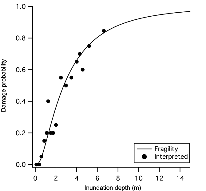
1.Analyzing the relationship between intensity of hazard, human society and the impacts to the society
When external forces such as earthquake and tsunami act on human society, several types of damages are caused. In this topic, we apply mathematical approaches to analyze the relationship between hazard such as earthquakes and tsunamis, and the amount of damage that changes according to the human society conditions (Ex.1).
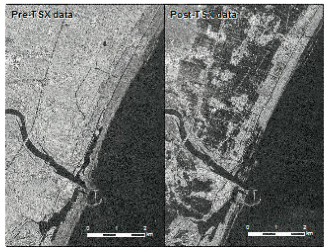
2.Development of methods of rapid damage assessment with big data
Remote sensing data such as satellite images, aerial photos and drone images, position information from GPS, social media information are useful for understanding wide area damage in a short time. Based on these observation/monitoring data and web information, we will develop a method to comprehend the damage caused by a natural disaster within a short time (Ex.2).
3.Study of a decision makings to minimize disaster impacts with big data analysis
We will study decision makings at the time of “Before disaster”, “Response”, “Recovery” and “Reconstruction” to minimize disaster impacts by integrating the research results from 1 or 2 described above and other data to be analyzed such as location information from GPS, social media information.
4.Study for implementation of the data analysis result
In order to make optimum decision making related to disaster management, we will conduct research on how to convey information obtained as a result of data analysis. Depending on the circumstances, the information necessary for optimal decision-making might be different. Through social surveys, we will study how to convey appropriate information to minimize the impacts due to natural disaster.
 |
 |
|
| Ex1:Function of tsunami hazard and building damage | Ex 2:Remote sensing data to be used for analysis |
Key Publications
- Gokon H, S. Koshimura and M. Matsuoka, Integration of Building Unit Based and Zonal Based Approaches to Detect Washed-away Buildings in a Tsunami Affected Area Using TerraSAR-X, 2016 Vol. 16 Issue 3 pp.3_147-3_156(In Japanese)
- Gokon H., S. Koshimura and M. Matsuoka, Object-based method for Estimating Tsunami-induced Damage using TerraSAR-X data, Journal of Disaster Research, vol.11 (2016), No.2, pp.225 - pp.235
- Gokon H., S. Koshimura, K. Imai, M. Matsuoka, Y. Namegaya and Y. Nishimura: Developing Fragility Functions for the Areas Affected by the 2009 Samoa Earthquake and Tsunami, Natural Hazards and Earth System Sciences, Vol. 14, pp. 3231-3241, 2014
Equipment
PC, Image analysis software, GIS software
Teaching policy
Through research activities, abilities to gain insight into the problems hidden in society and the ability to think things logically will be trained. My laboratory mathematically analyzes a large amount of information and exploring ways to use them for decision making. At the same time, we aim to contribute to building a safe and secure society through research activities. Therefore, we place importance on investigating the actual site such as affected areas, and making a tool that contribute to contribute real society.